
We offer advanced unmanned services for industrial and maritime sectors, including air and underwater drone operations. We specialize in visual and thermographic inspections for buildings and infrastructure, mapping and laser scanning, maritime surveillance, and energy sector inspection and monitoring.
In addition to smaller drones, we use unmanned helicopters to provide extensive services to power grid companies and agricultural and forestry sector. Our Yamaha FAZER R unmanned helicopter can fly up to 90 minutes with full load of 35 kg.
We provide a safer, more efficient, and environmentally friendly alternative to traditional inspection methods.
Buildings, thermography, and infrastructure inspections are some of AERSEA`s core business segments. We annually inspect buildings for ca 50.000 square m BYA in Norway.
In recent years, we have worked for Statsbygg on roofs, facades and thermography for all major buildings and structures. Our portfolio include iconic buildings such as Norwegian Institute of Public Health, Norwegian Opera House, Oslo Courthouse, Norwegian foreign ministry, National Archives of Norway, Norwegian Government offices, Norwegian Academy of Music, The National Museum of Architecture, Bergen Courthouse, University of Stavanger etc.
Inspections and thermography using drones have proven give excellent results.
From Statsbygg:
Forestry
Accurate data acquisition in forests is often time-consuming, labor-intensive, and expensive, particularly in hard-to-reach areas with limited access. AERSEA addresses these challenges by utilizing industrial-grade unmanned helicopters from Yamaha Motor Japan. This technology enables us to efficiently and safely collect high-quality, accurate data across vast areas, providing forest owners and stakeholders with a sustainable and effective solution for forestry management.
Our services include tree counting, assessing tree density and alignment, measuring trunk diameters, topographical mapping, and creating detailed terrain models. We also offer logistical support by delivering tools to remote locations, all contributing to more efficient forestry management and enhanced forestry asset value.
Agriculture
Smarter ways to sustainable agriculture is necessary to obtain a steady food supply. Using technology, and by using drones, AERSEA provides insights into crop health, givingfarmers precise information to make better decisions about nutrient application and disease management. Data driven decisions.
With accurate and timely information about the state of their crops, farmers can apply fertilizers and treatments precisely where needed, avoiding unnecessary resource wastage, and reducing environmental impact. This targeted approach to crop management enhances overall yields while minimizing costs.
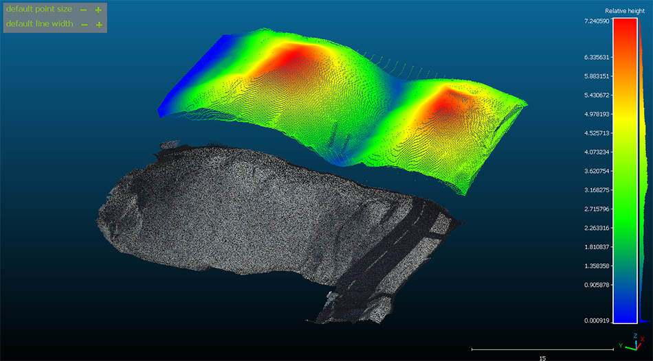
AERSEA delivers survey grade high accuracy data and precise orthophotos, point clouds, terrain-, and 3D models. Using high resolution cameras and a very precise LiDAR we can capture very precise data from the ground giving us a good basis for creating our datasets.
In close cooperation with The Norwegian Coastal Agency we measured and created accurate high resolution point clouds and orthophotos of in total 63 wave breakers outside Andøya and Lofoten during the summer months. See below example photo from Å, Moskenes kommune.
AERSEA is using industrial grade unmanned helicopters to perform power line inspections. This method has proven to be a safer, more efficient, and environmentally friendly approach to inspect power lines. Our partner Yamaha Motor Japan has more than 30 years’ experience with more than 2 million flying hours to back up our statement.
Laser scanning to capture data and to get information about surrounding vegetation, thermal imaging to detect faulty components, and high-resolution camera to detect the state of the utility poles and its components, all this is possible with our method. We can remove the buildup of snow and ice during wintertime faster and safer using our unmanned helicopters.
AERSEA can deliver cost efficient and fast underwater surveys and inspections using our industrial grade but lightweight inspection ROV.
Depths till 300m and with high quality imagery gives good value for money doing inspections on underwater cables and anchor mooring, ship hull anodes, control surfaces and more.
Call us for a short talk or send us a mail, in case you have a problem to solve or if you are just curious about what we do.
You will always meet one of our team members, never a chatbot.
Sitemap
Contact information